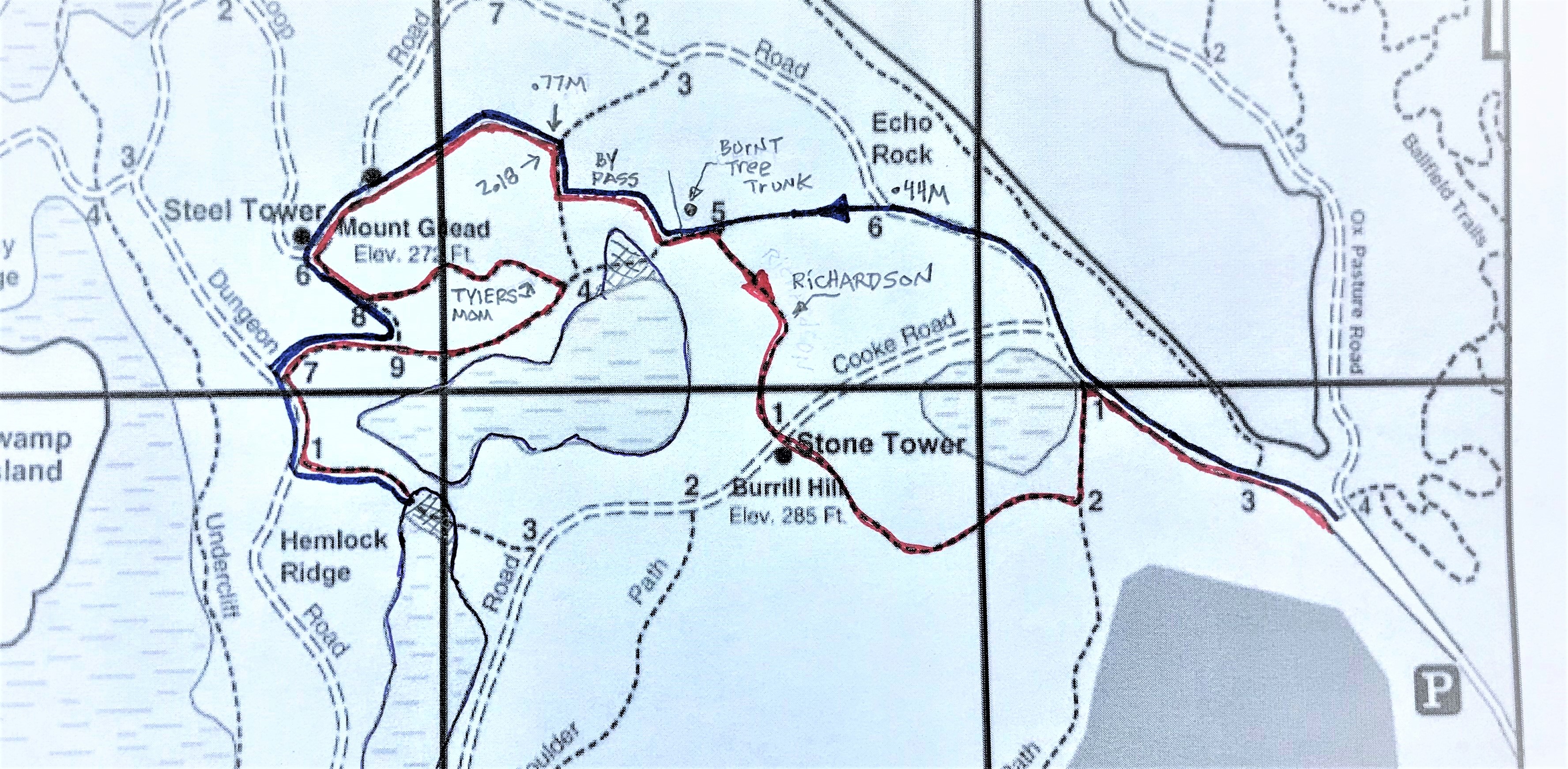
GW6 Short 3.15 Miles
Greatwood Side- Trails 80 % Fire roads 20%
Bring a map. Bring written directions (see below)Suggest you check course first before running for time.
Suggest you run in pairs. Carry a phone.
DO NOT RELY ON THE ORANGE MARKERS AS THEY MAY BE MISSING!!
The prime stimuli for change in direction are at the intersections.
If you see a path to your right or left that is not mentioned in the directions run straight.
ATTENTION: START IS AT GREEN GATE AT END OF PARKING LOT!
Start: Great Woods Road beginning of the trail head at green gate
.44M: Left onto D5-6 (2 markers)
40 Yards after Richardson Path: Right onto the Dan Small By-Pass (2 markers)
.66M: Right at T intersection (uphill)
.77M: Left (2 markers) DO NOT RUN THE CURVE TO THE RIGHT!!
Left onto Fire Road heading to Steel Tower (2 markers)
.98M: Left onto C5-6. The grid sign is at the top of the climb on the left.
1.04M: Bear Right at the Y (C5-8) (1 marker) ahead.
1.08M: Right onto C5-9. (2 markers)
Left onto Dungeon Road (C5-7)
1.20M Next Left onto C6-1. Run on this path until you meet the water.
1.44M: TURN AROUND
Right onto Dungeon Road (C6-1)
Next Right onto C5-7
1.54M: Right at C5-9 (Going from C5-7 to C5-9 ends in T…the map indicates no turn).
Caution: You are heading to a two path intersection at D5-4. No grid sign on tree.
1.73M: Take Hard Left onto Tyler Mom’s Path. (2 markers) Ignore the arrow on sign.
At top of path go Right onto Fire Road (C5-6)
2.01M Go right to the path that you ran up earlier. Look for 2nd orange trail colors on right on the trees. (2 markers)
2.18M: Take Right (2 markers)
2.27M: Left Look for Dan Small’s “bypass path” on the left.
Take Left at end of By-Pass
Right onto Richardson Path to Stone Tower (D5-5)
Straight across fire road (Cooke) onto D6-1(Richardson Path continued).
Take Left at T (Cornel Path E6-2)
Right onto Great Woods Road (E6-1) to
Finish bottom of hill and Green gate. 3.15 Miles
===============================================
GW6 Long
VIRTUAL - GW Long
6.79 Miles – Greatwoods Side Fire Roads 84%- Trails 16%
GW-Cornel-Richardson-Cooke-Dung/Way-path-PB-Wald Pd-PB/GW-path-MID-GW
The miles in parentheses is from the start. These were wheel measured. Your GPS might differ. The miles in combination with description can be helpful.
START:
GW long -Green Gate start... Near Gannon
Left- Cornel Path E6-1 (0.39 mi) Cornell sign 20 ft up on tree.
then take first Right- Richardson Path E6-2 Richardson sign 10 yards after turn.
then past Tower and
Left- Cooke Rd D6-1 (0.73 mi)
Left- Dungeon Rd C7-1 (1.25 mi) it soon becomes Waycross Rd - take
Left- C7-3 (1.87 mi) This path is near the top of the long incline.
Right- C7-8 this soon leads to a twisting downhill path. You will pass grid sign C7-6
Soon after you come to a T. No grid mark. On the map it appears that there is a grid mark (C7-6) but you passed it 30 yards before the T intersection. (2.08 mi) Take a
Right- at T Follow the Green Trail Blazers straight to Pennybrook
Right- on Pennybrook (2.17 mi)
Left – B5-7 You are Waldon Pond Rd (3.08 mi) Go to the end at Black Gate. Stables are in front of you. (3.78 mi)
Turn around- Head back to B5-7
Left – B5-7 Pennybrook it soon becomes Greatwoods Rd
Right – C4-3 This path is the first path after you pass the large right turn on Greatwoods close to the pond. (5.19 mi)
Left- C4-4 (5.30 mi) This will lead you to the lower portion of the Goat Path
Right- up the Goat Path. Sign is on tree on right. (5.49 mi) Last path of the course. The trail colors change from Blue to Green. Go straight regardless of trail color change.
Left- Middle Rd (Dungeon Rd) C5-2 (5.64mi)
Right – onto Greatwoods Road to the
Finish Green Gate Near Gannon 6.79 miles